Introduction
A topographic survey establishes the physical features and the elevation of a given parcel of land. It provides a highly accurate plan of the site footprint to help decision-makers in various sectors, including all manner of architecture and construction industries, mining, and any other industry in which a comprehensive knowledge of physical space is necessary or desired.
A topographic survey can help developers gain a complete understanding of their site to help them avoid delays and costly mistakes associated with unforeseen problems.
In India, topographic surveys have proved invaluable in resolving boundary issues that have gone on, in some cases, for years. After completing a topographic survey, the surveyor can overlay it with the legal boundary to determine any changes over time that have created vagueness and disputes.
What is a Topographic Survey?
A topographic survey accurately depicts a given parcel of land in three dimensions. In traditional usage, a topographic map shows the height, depth, size, and location of any man-made or natural features and the changes or contours in elevation throughout the parcel. In modern usage, a topographic map involves generating elevation data in a digital form (DEM).
A topographic survey may include the following features.
- Boundary lines
- Buildings and structures
- Street furniture (such as benches, post boxes, phone boxes, street lamps, traffic lights and signs, public transport stops, public toilets, monuments, public sculptures, and waste bins).
- Trees, bushes and vegetation
- Water channels (such as rivers, streams, ponds and lakes)
- Ground heights and contours
- Drainage features
- Water levels
- Utility Poles etc.
Architects, engineers, building contractors, government, and others utilize the topographic maps to visualize their sites accurately to support design improvement or development on a site.
What are the types of Topographic Surveys?
Topographic Surveys are classified based on the purpose of the survey and desired output, like a general topo survey, mortgage survey, boundary survey, and As-Built Survey, Hydrographic Survey, bathymetric survey, etc.,
Let us see some specific forms of the topographic surveys.
As-Built Survey
All construction projects start with the Site Plan, which sets out the blueprint for the entire project, including present and proposed conditions on a given site.
As-Built surveys ensure that all the construction has been constructed properly and built precisely according to the plan. It is used to get the completion certificate from the local body.
As-Built survey Provides essential information that requires during construction and for later projects. They serve as a basis for recording all changes obtained during the work to get information about any design changes quickly.
For existing structures, an As-Built Survey finds if a structure or object is changing shape or moving. It is also known as a deformation survey.
Taking three-dimensional positions on specific points on an object and then letting time pass before retaking and measuring the points can determine whether a structure is shifting or moving and by how much.
Mortgage Survey
Mortgage Surveys are simple forms of topographic surveys usually useful for Banks and lending institutions when they provide financing to show that no structures are encroaching on the property.
Hydrographic Survey
Hydrographic and Bathymetric both refer to submarine topography. Bathymetric surveys deal exclusively with underwater profiles, which measure physical objects of a water body.
Hydrographic surveys gather data relating to any water body, and the data collected may include:
- The water depth.
- Bottom contours.
- Shape and features of the shoreline.
- Characteristics of tides, currents, and waves.
- Recording high water mark levels.
- The physical and chemical properties of the water.
- Location of fixed objects.
- And landmarks for navigational purposes.
It gathers information for engineering or resource management purposes, such as hydropower plants, Dock and harbour engineering, Irrigation and Flood Control Management, etc.
What are the steps involved in a Topographic Survey?
A topographical survey process includes:
- Gathering information about the project and client requirements.
- Planning the schedule and pricing
- Collecting survey data on the ground
- Processing data and preparing the final survey report
- Cross verifying by a senior member of the staff
- Delivery of the final survey record to the customer.
How long does it take to complete a Topographic Survey?
Every site is different, so there is no simple answer to how long it takes to complete a topographic survey. The duration of a topographic survey process may take one day or up to a week or more, depending on:
- Area of the project
- The complexity of the terrain.
But, as a guide, you can expect a topographic survey to take between 1-5 days using Total station – often seen by roadsides on tripods.
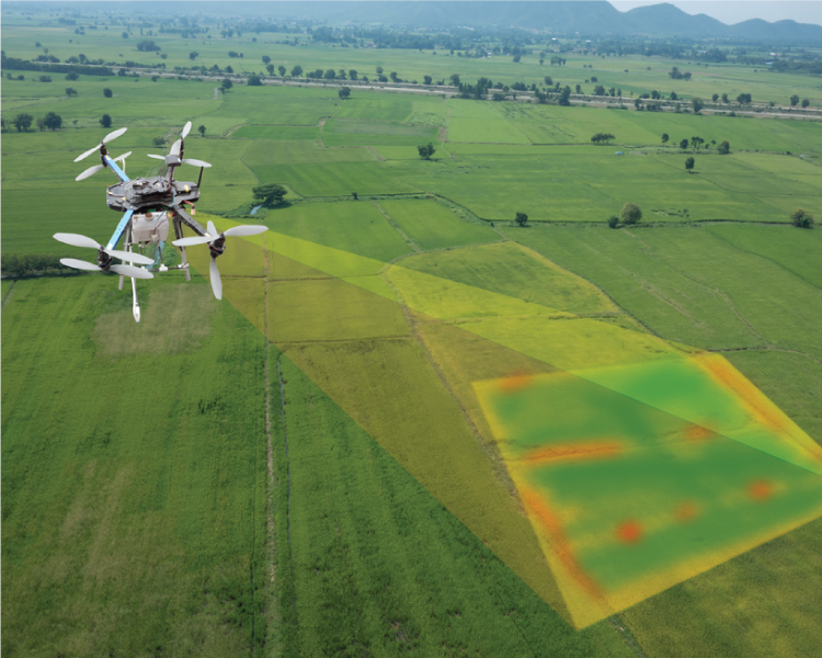
These days, many topographic surveys are done using drones. Drone technology has made both surveying and completing the plans a much quicker process.
The most time-consuming topographic survey affects the overall cost of land surveying. Once project time is estimated, a work schedule is planned with the client, including additional resources to meet a particular project milestone.
How Topographic Surveys Are Used?
Commonly, topographic surveys are used for:
- Construction and architectural projects
- Environmental restoration and property improvements.
- To fulfil regulatory requirements for construction codes.
- Guidance for setting upgrading or drainage ditches.
- Stockpile and volumetric calculations.
- New road layout formation.
- When land is developed for one purpose it is used for another purpose.
Who needs a Topographic Survey?
Architects need a topographical survey to create a 2D and 3D design for a construction project. This design can be presented to decision-makers for approval before groundbreaking.
Engineers might use the topographic survey to see the land surface elevation and determine if there is a requirement for cutting and filling to modify the grade of the property.
Suppose a building site is limited by significant topographical challenges, such as a steep grade, existing man-made structures, or other problematic conditions. In that case, a topographical survey helps before construction begins to ensure the proposed design will work in these conditions. Governmental agencies also use topographical surveys when making and enforcing construction and zoning regulations, evaluating existing infrastructure and needed revisions, and considering environmental projects. Other industries like Forestry, geologists, Hydrologists, and Formers are also using a topographic map.
Why is Topographic Surveying so important for Architects?
Architects expect accurate topographic data of their client’s site to design their project suitably for the terrain. An accurate survey of all the features is essential for planning, designing, and construction. Any features that are not surveyed can cause costly delays at any stage of the development.
Does the Topography of the terrain affect Architecture?
Yes, of course, the topography of the terrain affects architecture. The ground provides the primary support for the building. How the structure meets the landscape is a vital part of the exterior design. If you are building on a highly sloped site, an architect must consider the site’s slope in determining the finish floor elevation and need multiple entry levels to get in and out of the building. Even in an urban setting where the site is relatively flat, the topography is still an issue. Sometimes, it becomes even more valuable to review flat land to ensure you have enough slope on adjacent surfaces to get water away from the building.
Do I need a Topographic Survey?
A topographic survey is essential if you plan any land development or construction project from a simple extension to your home to an entirely new estate. In many regions, it is a legal requirement too.
What are the benefits I will get from a Topographic Survey of my site?
- Suppose you obtain the correct information at the early stage of the project using a topographic survey or any other land survey. In that case, it can save considerable time and reduce your working cost.
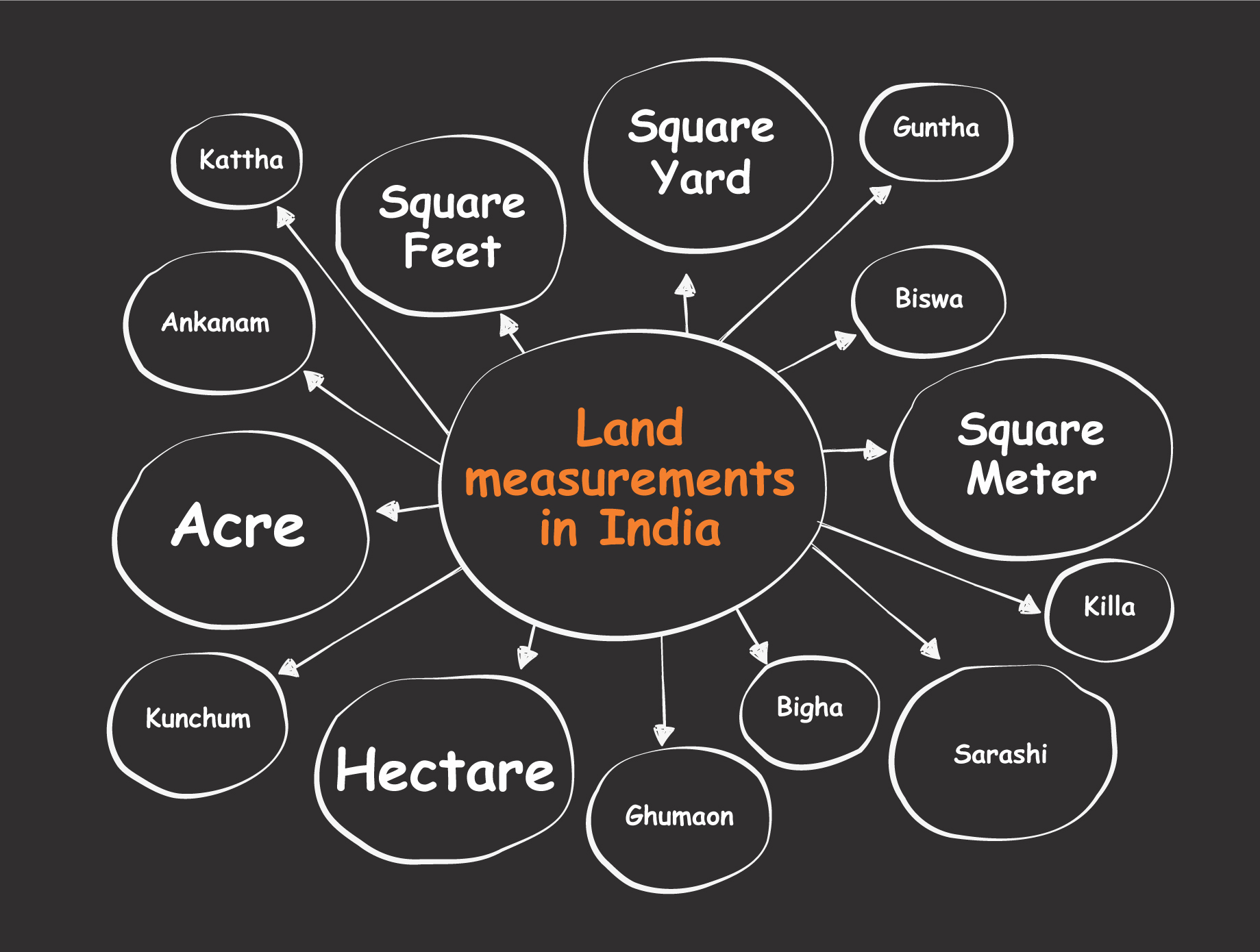
- A topographic survey will provide you with accurate land measurements and give you a clear indication of your existing site condition.
- A topographic survey will help guide decisions regarding the planning of new buildings, the re-positioning of your current boundaries, and the design of drainage schemes for your site.
- Conducting a topographical survey brings greater certainty to any planned development by reducing the risk of terrain-related costly errors that you could make without an accurate picture of your site.
- If you have a proper understanding of your land’s topography, you will have a better idea of the condition of the land and its potential impact on the type of construction that you could build there.
Is there any special equipment used to conduct a Topographic Survey?
Topographic surveys are carried out using:
- Total station
- Digital Levelling Instrument
- DGPS with Real-Time Kinematic (RTK)
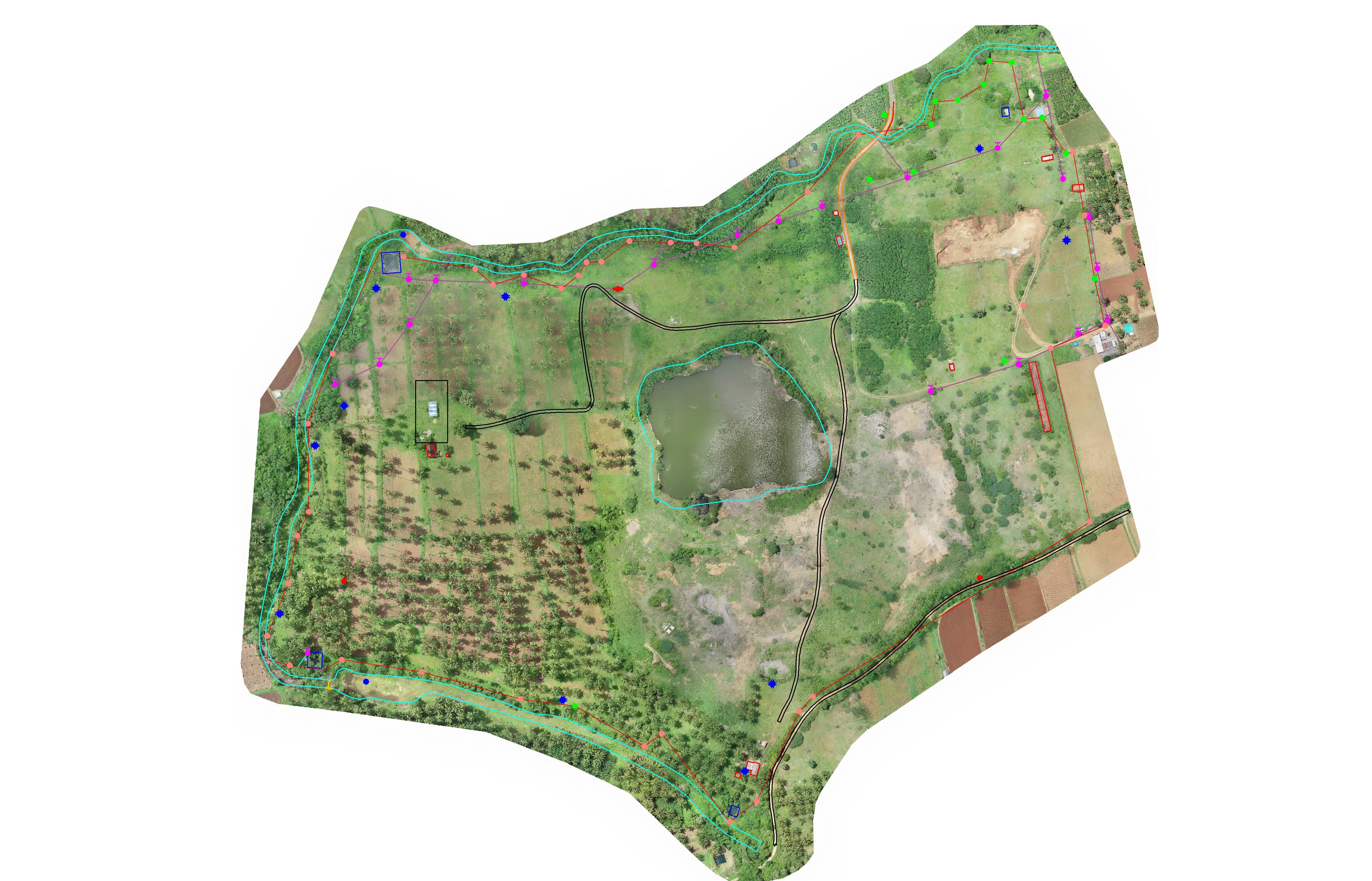
- Drone Photogrammetry
- Lidar system
Depending on the project specification and terrain conditions, these technologies are used either jointly or interchangeably.
How to read a Topographic Survey map?
Surveyors can represent topographic data in multiple formats; the output is subject to the client’s requirement.
In general, a topographic map contains the following details.
Map Scale: Maps come in various scales, covering areas ranging from the entire earth to a small parcel.
Contour interval (Vertical Scale): All survey maps have a horizontal scale, whereas topographic maps also have a vertical scale to determine a point in three-dimensional space.
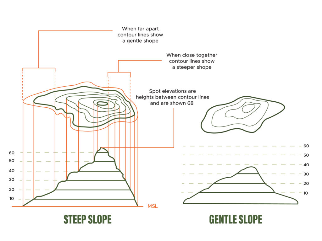
Contour Lines: Contour lines define terrain elevations and lines on a map produced from connecting points of equal height.
The following are general properties of contour lines:
- Contour lines do not bisect each other.
- Closely spaced contour lines describe steep slopes, contour lines spaced far apart describe gentle slopes.
- Contour lines trend up valleys and form a “V” or a “U” where they cross a stream.
North Symbol: The direction of the north is located at the top of the map.
Legends: Legend in the topographic map explains what the map’s symbols, lines, and colours represent.
Grid Line: A grid is a regular pattern of parallel lines intersecting at right angles and forming squares; it identifies precise positions. It helps to locate topographic features accurately on the ground(or map).
How much is the cost of a Topographic Survey?
Once again, this very much depends on the size and complexity of the task. The cost of a topographic survey majorly depends on the time we need to spend on the project. The more days required to complete the survey, the higher the price will be. The survey time will depend on
- The total extent of the land.
- How visible the ground is.
- The level of detail and accuracy.
- The location of the site.
- The present condition of the terrain.
- The technology used.
As a guide, you can expect the prices to start from around 6000 INR + GST for a small survey.
Modern topographic surveys carried out by drones usually only require one operator and can be completed in a fraction of the time, so this is usually the more affordable option. Timing will still be a factor, but prices start from around 50,000 INR + GST for a simple survey.
Check this blog on how to reduce the cost of the survey on your next project.
How do I find the right Topographical Specialist?
Due to the financial risks associated with site planning and investing, you need specialists in this field who can keep you protected. While surveyors are all professionals, you may have specific standards when choosing the right one to survey your property. Below are some tips that you might want to follow:
- Check the credentials – of course, you would like to opt for a qualified surveyor.
- Take note of experience – Credentials are good, but experiences are better.
- Ask about work ethics – Ethics play a significant role to establish a working relationship between you and your surveyors; hence it should be one of your main concerns.
- Ask about accessibility- communication is a crucial aspect of every relationship you have, whether personal or professional.
- Be in the know of your prospective surveyors’ reputations- This encompasses many things, from the quality of work to a professional relationship with clients.
- Determine the cost of services – although it shouldn’t be your only concern, the price is undeniably important.
At RVS, our portfolio includes surveys for several major clients. We pride ourselves on using the latest technology to provide high-quality, precision topographic maps at affordable prices. Whatever your land development or construction project, if you need a fast and affordable topographic survey, let’s talk.
The Takeaway
Topographic surveys show features of the land and its elevation and have a lot of practical utilization. Before beginning any infrastructural project, the topography survey is vital. Any infrastructure project can’t be successful if the elevation and features of the land are not accounted for in the development, improvement, or construction plans. Topographic surveys are irreplaceable because the details they provide can completely alter designs to build. If you’re looking to start a project and conduct topographic or other surveys, contact us today.